Orienteering Merit Badge
Kings Mountain National Military Park
35.141090, -81.376353
7 March 2020
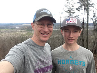
Nathan completed the Kings Mountain NMP, COK Yellow course, hosted by the Carolina Orienteering Klubb. The Yellow course consist of 12 controls over a total course length of 3.3 km. Weather was sunny with mild temperature in the mid 40's and strong gust of wind. This was Nathan's second orienteering event.
COK provided Nathan a standard orienteering topographic map with a Scale 1:7,500 and contour interval of 5 meters. Nathan used his personal compass, a SUUNTO A-10 model.
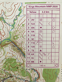
It's often important if not just very helpful to understand the meaning of the orienteering clue symbols. Nathan spent a fair bit of time looking for control 7 (flag 118).
A B C D E F G H
Column C: which feature? northeastern (relative to the control marker)
Column D: the symbol tells us the feature is a 'cliff' (however, the map legend shows the control marker is somewhere near a passable rock face adjacent to a boulder cluster)
Column E: details of the feature (in this case no details are provided)
Column F: dimensions of the feature (typically shown as height in meters & length/width)
Column G: location of the marker; the symbol tells us that the control marker is located at the foot of the feature (i.e., at the foot of the rock face cliff)
Column H: other information (none provided in this case)
The Control Marker 7 was very difficult to visually see because it was hidden within the rock face cliff. Nathan literally walked right past the marker without even seeing it on the ground! He ended up spending about an extra 10 minutes searching for this one marker before realizing the clue would help him understand where to look for the marker! Lesson Learned
It's fun to keep an eye out for 'stuff' in the forest. In the photo above is a small leaf couplet known as 'heart leaf' because of its shape similar to a heart. This plant is in the genus Hexastylis and is often found on north facing slopes of small streams in rocky soils. There is a species that is federally protected (H. naniflora) with the same leaf shape. Nathan and I looked for the small flower (purple colored urn shaped) but the plant is not quit in flowering season so we couldn't tell if this is the protected plant or not. However, keep your eye open for cool nature stuff!
The woods were thick with small trees and undergrowth. It's a good idea to spend some time reviewing the legend to understand tricky areas of the forest that are either easy, slow, difficult, or fight in order to choose a route that is the most appropriate between controls. It's not always a straight line that is easiest and typically the best route navigates around tricky spots.


